Land Surveyor & BIM Specialist | Topographic 2D/3D & Scan to BIM Expert
Rabat,
Morocco
I am a professional Land Surveyor with extensive experience in creating high-precision 2D and 3D topographic plans. I specialize in processing surveying data and transforming it in...
Civil 3D and CAD specialist with strong experience in detailed topographic mapping, digital terrain
Russia
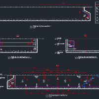
I am a Civil 3D and CAD specialist with over 25 years of experience in topographic mapping, digital terrain modeling, and civil infrastructure documentation. For the past 7+ years...
AutoCADAutoCAD Raster DesignAutodesk Civil 3DBIM Credo Topoplan16
more
I am a qualified Surveyor with a degree in Surveying and Geographical Information Systems and over 8 years of professional experience in AutoCAD design, Civil 3D, and GIS mapping....
2D & 3D Animation2D & 3D CAD Design2D & 3D CAD Drawings2D & 3D Floor Plans18
more
I am part of Good-ID, a Swiss outsourcing company established in 2012 and headquartered in Geneva. We provide international remote teams and multilingual services (French, English,...
2D & 3D Architectural Design2D AutoCAD2D/3D AutoCAD3D Architectural17
more
I am a Civil 3D and CAD specialist with over 22 years of experience in topographic mapping, digital terrain modeling, and civil infrastructure documentation. My career spans full-c...
Land Survey Drafting ,LiDAR data and GIS specialist
Bhubaneswar,
India
I can support for drafting services and different GIS & CAD projects (Survey Mapping, Structural, Architectural design, Structural calculations). We are expert for drafting for Bo...
Civil Engineer with 15+ years of experience in road design, grading, topography, drainage, and infrastructure projects. Specialized in Autodesk Civil 3D, roadway modeling, earthwor...