Hire freelance 3D aerial design services for your company
We help companies find vetted 3D aerial design firms and rendering services on demand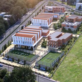
At Cad Crowd, we bring your business to the next level with skilled, professional 3D aerial renderings. Clients expect high-end computer-generated imagery as a standard element of every job. Consistent, top-of-the-line, professional 3D aerial renderings help brand your business and create that valuable, lasting impression. Connect with Cad Crowd, and we'll connect you with a 3D aerial rendering services firm for a free quote today!
Cad Crowd offers 3D aerial rendering services for a variety of industries:
| Architecture | Manufacturing | Transportation |
| Energy and utilities | High tech | Life sciences |
| Aerospace and defense | Environmental planning | Marine and offshore |
| Agriculture | Marketing | Media |
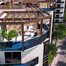
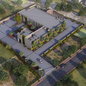
3D aerial rendering for architecture, development, and construction
Cad Crowd’s technology leaders are shaping the future of the built environment daily alongside industry-leading architects, developers, and builders. Our freelance CAD designers produce top-of-the-line 3D aerial renderings that help you better communicate with stakeholders.
3D aerial renderings help architects create more accurate designs. Builders increasingly analyze construction sites with 3D-visualized data for construction planning and management. They’re also invaluable for marketing new developments. Professional 3D aerial renderings will increase your efficiency on every job.
Let Cad Crowd’s experienced CAD designers do the work. We’ll use your photo, video, or 3D model to create stunning stills or fly-throughs for all your professional architecture, development, and construction needs.
Don’t have a 3D model? We’ll create one for you! Click here to learn more about Cad Crowd’s professional 3D modeling services, and read on to find out how 3D aerial rendering is impacting many different fields.
Mining and energy
If you work in mining and energy, you already know that 3D aerial rendering exponentially increases exploration productivity. Drone-to-3D workflow enhances infrastructure inspection and maintenance, decreases employee safety risks, and increases materials, operations, and security efficiency.
Visualization with 3D aerial rendering also boosts a firm’s capacity for data analytics. Cad Crowd expertly generates accurate contour maps that help share insights between collaborating firms. We work hard to understand your data and transform your plans into compelling 3D visualizations.
Cad Crowd gives each 3D aerial rendering proposal personalized attention and a custom quote. Have something in mind? We’re standing by! Contact us to determine which 3D aerial rendering services company is right for you.
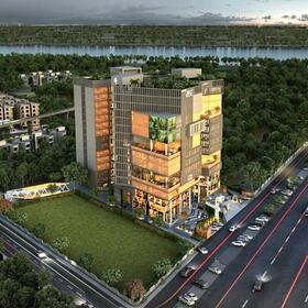
Industry
The 3D aerial design companies in Cad Crowd's extensive network produce accurate, consistent 3D aerial renderings for diverse industrial uses. Whether you’re modeling a refinery, building a factory, monitoring changes over time, or showcasing a new product, our designers create sketches, plans, and photorealistic renderings that help bring your project to life.
A great CAD design simplifies complex technical data into engaging images that communicate the right message. Professional renderings from Cad Crowd impact worldwide at meetings and trade shows and on websites and social media. Your 3D aerial renderings will help you raise funds, facilitate reviews and permitting, and expertly market your firm.
With our in-depth understanding of CAD design and a proven track record, Cad Crowd increases your team’s efficiency while furthering your company’s goals. Get in touch for a free quote today!
Agriculture and life sciences
Farms and agribusinesses regularly save time and money using 3D aerial renderings for crop surveying. Cad Crowd’s CAD specialists add 3D visualization to drone imagery to help map out land and irrigation systems. Projects that have traditionally been time-consuming become easy with 3D aerial rendering technology.
Scientists use a similar workflow to study the earth’s ecology. Drone-to-3D visualization replaces noisy and intrusive helicopters for monitoring and visualizing the health of our planet. Using 3D aerial renderings, researchers gain valuable insights into resource and habitat management.
Cad Crowd works with owners, managers, scientists, governments, and operations & maintenance teams using drone-to-3D workflow to monitor and manage their assets.
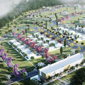
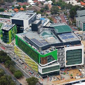
City rendering and smart cities
The design of smart cities is a growing trend nowadays and with good reason. Technology enhances business productivity and is also improving the urban environment. Engineers use drone-to-3D workflow to expedite road construction and maintenance, plan airports, pipelines, and transmission lines, and perform complex maintenance inspections. Cad Crowd supports urban planning by rendering accurate cityscapes and transportation models. We supply a variety of infrastructure projects with detailed, real-world visualizations.
Film and game development
It should come as no surprise that the film industry was one of the first fields to use 3D aerial rendering. For example, in 2017, the production company Aerial MOB was awarded the first-ever Emmy for outstanding technical achievement in drone cinematography.
Drones significantly lower production costs and expand a filmmaker’s creative choices. Films like The Circle, Guardians of the Galaxy, and La La Land have recently used drone-to-CGI workflow. Apple Music uses drone footage, and advertisers worldwide use drone technology to captivate new audiences.
The $100B game industry also uses drones for 3D aerial rendering. Drone photogrammetry is the process of gathering geometric measurements from real-world objects. Game producers use it to map terrain, creating realistic maps for PlayStation, Nintendo, Xbox, PC, and mobile applications.
Cad Crowd comes in when computer-generated imagery (CGI) is added to drone footage. We’ll advise you on all your drone-to-CGI needs for film and entertainment. A professional CAD designer is standing by to chat about your 3D aerial rendering project.
Click here to learn more about drones' present use and future potential!
Media and marketing
Before advanced 3D rendering technology was available, photographers needed helicopters to create 3D aerial images and videos for marketing and advertising. But that’s no longer the case. Not only do Cad Crowd’s CAD designers create various technical designs, but they also create stunning 3D aerial renderings for advertising.
Rendering an ad campaign requires specialized expertise. Whether your project involves landscapes or cityscapes, we'll prepare a comprehensive and cost-effective proposal. Contact Cad Crowd today!
News outlets
News outlets use drones to add drama to their storytelling and capture cutting-edge footage that’s impossible to achieve with traditional equipment. For example, CNN has the news network's most advanced drone fleet. CNN Air flies hundreds of missions worldwide to gather its news and information.
CNN Air also uses its drone fleet to create digital models of our planet. On the cutting edge of drone-to-CGI workflow, the network explores virtual reality cameras and live graphics overlay for augmented-reality applications.
Let an experienced CAD designer guide you through the fast-paced world of 3D aerial rendering. Take a look at Cad Crowd’s 3D rendering portfolio, and contact us for a detailed quote.
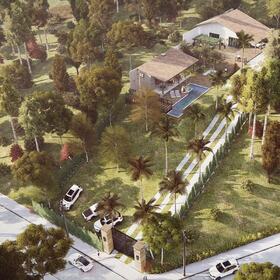
Recreation and leisure
Landscape photography and extreme sports were the first to use drones for aerial imagery in recreation and leisure. In 2013, for example, SenseFly made a splash when they created a 3D drone map of Switzerland’s Matterhorn peak. Technically impressive and incredibly detailed models like these help climbers and skiers develop safer navigation strategies for complex terrain.
Need 3D aerial renderings for recreation or leisure? Send Cad Crowd your proposal today. We’ll analyze your requirements and connect you with a freelance CAD designer who can meet your project’s needs.
Tools and techniques for 3D aerial rendering
“I’m old school—I came into the profession back in the day when we built big physical models to understand size, scale, and experience. Before having VR, it was always challenging to reconcile how you do that.”
— Hao Ko, Designer of NVIDIA HQ in Santa Clara, California
Cad Crowd’s 3D rendering capabilities include, but are not limited to:
| Lumion | Photoshop | Revit |
| SketchUp | ArchiCAD | MicroStation |
| 3dsMAX | V-Ray | 3dsVIZ |
| Railclone | UAV | Sky-futures |
| Sky-X Systems | Cyberhawk Innovations | Sketchfab |
Making 3D models with a drone
Ever wonder how to capture a 3D model with a drone? Excellent-quality 3D aerial models are obtainable using only a drone and the appropriate apps. Here’s an excellent way to use a drone to capture a 3D model for your 3D aerial rendering project:
1) Pick the right time to fly. Avoid bad weather, but consider how specific lighting conditions affect the model. Overcast days work best because it’s easier to avoid strong shadows. Also, flying a drone around noon will keep the shadows as short as possible.
2) Map your flight plan. Apps like DroneDeploy (iOS or Android) will help to define your flight path.
- For flat terrain, begin the capture with nadir imagery, a process where images are taken from directly above in a back-and-forth, lawnmower-type pattern. If you’re making a model of flat topography, this type of overhead flight may be all you need to create your 3D aerial model.
- Overhead images won't be enough to model a structure or steep terrain. You’ll need at least two extra orbits around the object to capture imagery of the sides (obliques). Tilt the camera 45 degrees, then orbit the structure at the same altitude as your nadir flight. After that, the altitude was reduced by half, and the camera angle was adjusted to 90 degrees. Pro tip! Be sure not to capture the horizon in your oblique images.
3) Upload and process your images using a drone app (such as DroneDeploy) and process the imagery according to the app’s instructions. The app will stitch the photos together, and your 3D model is complete!
Combining drone footage with 3D aerial renderings
Once you have a 3D aerial model, Cad Crowd’s expert CAD designers can create the final rendering. Some possibilities to explore are flyovers, walkthroughs, fly-through animations, 3D aerial diagrams, augmented reality, and still images. Contact Cad Crowd today, and we’ll chat with you about personalized CAD strategies that will best suit your project.
Flyovers, 3D walkthroughs, and fly-through animations
Eye-catching flyovers, 3D walkthroughs, and 3D fly-through animations will elevate your project. Cad Crowd’s master CAD designers excel in creating accurate, photorealistic 3D walkthroughs and 3D flyover animations that showcase your project’s strengths:
- With satellite and aerial imagery overlaid onto digital elevation models (DEM), we will generate 3D Terrain / Google Earth superimposed renderings using Google Maps and height maps.
- We’ll texture your building model into a photograph or rendered landscape and work with you to create your desired backdrop.
- To complete a 3D flyover, 3D walkthrough, or 3D fly-through animation, we’ll set up the cameras, animate people, objects, and vehicles, and create scenes based on your unique requirements and project narrative.
Give us your project specs, and Cad Crowd will match you with a CAD designer with the specialized skills to create all-inclusive, professional 3D aerial renderings.
3D aerial diagrams
Cad Crowd’s 3D CAD designers will overlay vital information to make 3D aerial diagrams that personalize your message, whether a simple residential rendering or a large and complex landscape. You can choose a birds-eye view or a raised-eye view to see your data up close. Clients and viewers appreciate access to state-of-the-art visualized data.
Augmented reality
Augmented reality (AR) superimposes a computer-generated image onto a user's real-world view. Cad Crowd’s CAD designers can visualize 3D models directly overlaid onto the landscape. Augmented reality is the perfect solution for visualizing field location data, navigation, or managing all types of infrastructure.
Entertainment companies also use augmented reality to capture the imagination and create lucrative marketing opportunities. Real-world portals link directly to your company’s communications and marketing channels through social media platforms. Media audiences around the world flock to companies producing innovative AR strategies.
Still images
Cad Crowd’s professional CAD designers can render a setting for your 3D model, but if your goal is to embed a 3D model within an actual photograph, you’ll need to start with a high-quality backdrop. Your choice of photo can make or break the visual, so consult with Cad Crowd. We can help you select the right image. Then, we’ll take it to the next level by seamlessly compositing your model.
Chat with us today! Cad Crowd’s freelance 3D aerial rendering pros will listen to your needs and pick precisely the right CAD designer for your 3D aerial rendering project.
What is compositing?
Compositing an aerial scene
Compositing is a specialized CAD technique that’s both an art and a science. It combines visual elements from different sources to create a finished scene. Cad Crowd’s 3D technology experts use high-tech tools and creative experience to deliver compelling 3D aerial visualizations. Whether working with footage or placing a model inside a still photograph, Cad Crowd’s 3D rendering pros will use some degree of composting to create the final product.
Lighting, textures, and transitions
High-quality 3D aerial rendering is much more than a simple cut-and-paste operation. Cad Crowd’s skilled designers have the tools and techniques to model state-of-the-art lighting, textures, and transitions. We’ve mastered the art of aerial/atmospheric perspective, perhaps the most important creative skill for 3D aerial rendering.
Aerial/atmospheric perspective is a technique that simulates the real-world conditions of atmosphere and light. Air is not invisible. As light moves through the air, water particles, smoke, and smog reflect and refract the rays. This means that objects in a scene closer to the viewer will have more saturation, contrast, and detail. Objects far away will disappear into the color of the sky.
Using principles of atmospheric perspective, our experienced CAD designers add a new level of realism to professional 3D aerial renderings. They have decades of combined CAD experience and adhere to the highest standards in the 3D rendering industry. Contact us for a free quote today!
Compositing a 3D model into a scene
In addition to atmospheric/aerial perspective, Cad Crowd’s CAD designers use several technical tools to deliver compelling 3D aerial visualizations. One popular method is to composite utilizing a combination of Photoshop and V-Ray with a rendering program like 3ds Max. Ever wonder how this is done? Here are the general steps a Cad Crowd designer might take to complete your 3D aerial rendering project:
1) Develop a concept according to the client brief. Find reference images with a general mood that inspires the client. Create some concept images to show to the client.
2) Using V-Ray, a popular plugin for CAD rendering software, set up the introductory 3D scene, gamma, frame buffer, and subpixel mapping. Choose basic materials and reflectivity for the model.
3) Using the client’s backdrop image or frame, prepare cameras and approximate camera matching, then ensure that focal points match the horizon line. Accurately calculate the following technical and design elements:
Camera height
Three camera angles are commonly used for 3D renders: Eye level, ground level, and aerial views. Aerial views are used for 3D aerial renderings.
Camera angle
Your Cad Crowd designer will expertly choose your project's camera angle. For example, a one-point perspective works well for a top-down view, a two-point perspective best serves a viewpoint slightly above the horizon line, and a three-point perspective will give your project a higher aerial angle.
Perspective convergence
Perspective convergence is the illusion that causes parallel lines to appear to meet at a vanishing point in the distance. A short convergence will give a dynamic feel to your rendering, but a longer, more "relaxed" convergence is desirable for most 3D aerial renderings. You can chat with your designer about what you think is the most effective perspective convergence for your project.
Depth of field
Depth of field is a technical characteristic of photography that helps create photorealistic 3D renderings. It’s defined as the distance between the nearest and farthest objects that appear focused in a scene. A scene can have a short depth of field, where only images in the front are in focus, or a more extended depth of field, where the entire scene is rendered in sharp detail. This is another design choice that the client and designer should discuss.
Line of sight
When adding people, vehicles, and objects to a rendering, your professional Cad Crowd designer will ensure each element is placed on the same ground level and shares a standard line of sight. This is a design technique that takes years of practice and experience. It’s essential to achieving professional-quality 3D aerial renderings.
Balance
Last but not least, principles of design excellence include achieving the right balance in any composition. Balance doesn’t just mean symmetry. An asymmetrical balance can add a sense of dynamism to your 3D aerial rendering. Cad Crowd’s professional CAD designers will consult you on achieving the best compositional balance to convey your project’s message.
1) Once the design’s technical details are chosen, it’s time to create the scene’s aerial/atmospheric perspective expertly. The designer will note the direction of light sources in the backdrop image. Then, using a tool like V-Ray properties, they’ll set the render engine, indirect illumination, radiance map, light cache, multi mattes, etc., to match.
2) The next step is to blend each element into the scene using masks, extra texture, brushes, levels, overlays, and shadows. A designer may mask the rendering and further refine the blending. Details can be added using photographic references and the stamp tool. The designer can continue to blend the rendering into the background image using curves.
3) Custom brushes may add more detail while adjusting colors and contrasts. Your designer can overlay details like sky colors, vegetation, and lighting effects using principles of atmospheric perspective and the stamp tool. The client wishes to add dramatic lighting, light streaks, flares, and other 2D effects. Then, the designer will make final adjustments in global hue and saturation.
4) The designer will present a draft to the client for feedback and then make fine-tuned adjustments to the scene.
5) Your 3D aerial rendering is complete!
Freelance top-of-the-line 3D aerial rendering services
Whether you need one designer or one hundred, Cad Crowd provides the freelancers you need for all your 3D aerial rendering projects. We work with individuals in many industries to maximize their productivity and enhance the quality of workflow with top-notch 3D aerial renderings:
| Architects | Educators | Game designers | Landscape designers |
| Engineers | Film and TV producers | Real estate developers | Manufacturers |
| Scientists | Real estate agents | Photographers | ...and more! |
Using CAD in your daily tasks makes a better product. At Cad Crowd, we complete your projects on time and budget. We're experienced draftspeople, architects, engineers, and designers committed to helping your project succeed.
Cad Crowd will find the right contractor to create your 3D aerial renderings and ensure they’re viewable in your project’s optimal platforms. The result? Happy and engaged customers! Get in touch for your free consultation. At Cad Crowd, we’re ready to advise you on all your 3D aerial rendering needs.
Hire our 3D rendering services for your next project
If you're looking for assistance with your 3D rendering project, let us help. At Cad Crowd, we have a network of the best modeling and rendering designers. Contact us today for a free quote.

Brands we've worked with


Skills similar to 3D Aerial Rendering Services
- 2D AutoCAD Designers
- 3D Modeling Designers
- 3ds Max (3D Studio Max) Designers
- Adobe Photoshop Designers
- ANSYS Designers
- AutoCAD Designers
- Autodesk Fusion 360 Designers
- Autodesk Inventor Designers
- Autodesk Revit Designers
- CAD Designers
- CATIA Designers
- Design Engineer Designers
- Drafting Designers
- Mechanical Design Professionals
- Mechanical Engineer Designers
- Mechanical Engineering Designers
- Product Design Professionals
- PTC Creo Parametric / Pro-E Designers
- Rendering Designers
- SolidWorks Designers
- Trimble SketchUp (Google) Designers