Moussa Balla S.
Surveying Engineer | Scan to BIM, Point Cloud to Revit & AutoCAD | Civil 3D | Drone Mapping
 Rabat,
Morocco
Global rank:
8,357
/
152,293
Skill pts: 10
ArcGIS Pro
Autodesk Revit 2025, 2026, 2027
Piping Modeling Design
Scan to CAD
Topographic Survey
About
I am a surveying engineer (MSc in Geodesy) with hands-on experience on industrial, infrastructure and urban projects in Morocco and West Africa. I capture data myself (terrestrial and SLAM laser scanners, GNSS, total station, survey drones) and turn it into models and drawings that clients can build on.
What I deliver:
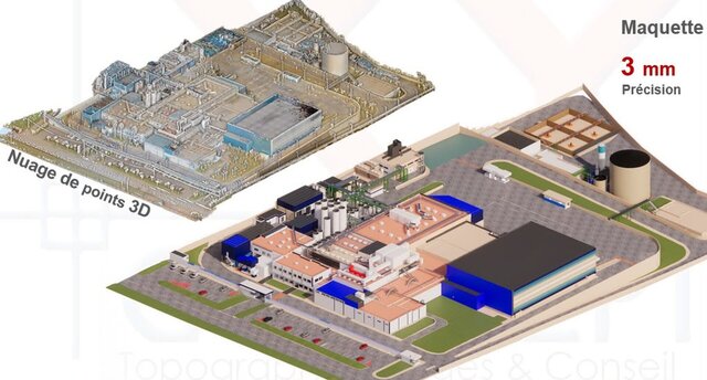
- Point cloud to Revit (Scan to BIM): as-built architecture, structure, industrial piping and equipment, LOD 200 to 300, with native RVT and IFC export
- Point cloud and 3D scan to CAD: AutoCAD plans, sections and elevations of existing buildings and plants
- 2D CAD and PDF drawings to Revit models
- Civil 3D: terrain models, contours, cut and fill, road and drainage profiles, as-built VRD drawings
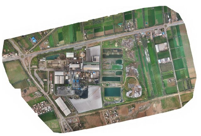
- Drone photogrammetry and LiDAR: orthomosaics, DSM and DTM, volumes, 3D meshes
- Clash detection and coordination in Navisworks
Selected work:
- As-built 3D models of two cement plants, from my own laser scans, used to install new equipment
- Revit models of existing urban areas for a City Information Modeling project
- 18,000+ ha aerial mapping and restitution for an urban planning agency
- Drone survey of a highway interchange, phosphate stockpile volumes, open-pit gold mine surveys
I check every model against the point cloud and mark what the scan does not show instead of guessing.
... more »
« less
What I deliver:
- Point cloud to Revit (Scan to BIM): as-built architecture, structure, industrial piping and equipment, LOD 200 to 300, with native RVT and IFC export
- Point cloud and 3D scan to CAD: AutoCAD plans, sections and elevations of existing buildings and plants
- 2D CAD and PDF drawings to Revit models
- Civil 3D: terrain models, contours, cut and fill, road and drainage profiles, as-built VRD drawings
- Drone photogrammetry and LiDAR: orthomosaics, DSM and DTM, volumes, 3D meshes
- Clash detection and coordination in Navisworks
Selected work:
- As-built 3D models of two cement plants, from my own laser scans, used to install new equipment
- Revit models of existing urban areas for a City Information Modeling project
- 18,000+ ha aerial mapping and restitution for an urban planning agency
- Drone survey of a highway interchange, phosphate stockpile volumes, open-pit gold mine surveys
I check every model against the point cloud and mark what the scan does not show instead of guessing.
Portfolio
Experience
-
Surveying Engineer – Scan to BIM and Drone Mapping
XYCONCEPT (Temara, Morocco) · Full-time
Aug 2025 –
Sep 2026
1 yrs 1 mos
Temara, Morocco
- Scan to BIM / Scan to Plant: laser scanning and as-built 3D models of two cement plants (Tetouan, Oujda) used to install new equipment
- Drone photogrammetry and LiDAR mapping: 18,000+ ha aerial survey and restitution for an urban planning agency; 5,000 ha soil and water conservation master plan
- Bi-monthly phosphate stockpile volumes from drone and 3D scanner data (point cloud processing, volume reports)
- Drone survey and detailed topographic plans of a highway interchange
- GNSS control networks (static), QA of orthophotos, DSM, DTM and restitution plans; supervision of field and office teams - Surveying Engineer – Laser Scanning and BIM Modeling GLOBETUDES (Sale, Morocco) · Full-time Jul 2024 – Jul 2025 1 yrs Salé, Morocco Scan to BIM, Scan to CAD and Scan to Plant projects with terrestrial laser scanners. Revit models of existing urban areas for a City Information Modeling (CIM) project and an urban renewal project, with realistic 3D renderings. High-precision tank calibration with terrestrial laser scanning (volume tables every 1 cm) at a desalination plant and other industrial sites. Volume calculations from LiDAR and drone data, as-built VRD drawings, slab flatness checks and acceptance of survey works for a university hospital, GPR utility detection and bathymetry.
- Surveying Engineer – Mining and Drone Surveys MS GEO CONSULT (Bamako, Mali) · Contract Jan 2024 – Jun 2024 5 mos Bamako, Mali Exploration phase of the Kobada gold mine: survey of exploration drill holes after drilling, and drone mapping of the whole mining permit (DJI Phantom 4 Pro and Advanced) with ground control points, processed into orthomosaics and terrain models.
- Mine Surveyor (final-year internship) Morila open-pit gold mine (Mali) · Internship Jun 2023 – Nov 2023 5 mos Bamako, Mali Mining department surveyor: ore stockpile surveys and volume calculations, RC drill hole surveys (exploration and grade control), blast hole and pattern surveys, pit surveys with a DJI Mavic 3E drone (RTK), stakeout of ore zones, crest and toe lines, slope monitoring and updates of the pit topographic plans.
Education
- National School of Engineers Abderhamane Baba Toure (ENI-ABT), Bamako Master's degree (MSc), Geodesy 2021 – 2023 Master 2 in Geodesy: geodetic networks, GNSS processing, adjustment computations, photogrammetry, remote sensing and GIS. Final-year project at the Morila open-pit gold mine.
- National School of Engineers Abderhamane Baba Toure (ENI-ABT), Bamako Bachelor's degree (Licence), Land Surveying (Geometre-Topographe) 2018 – 2021 Surveying, topography, cadastre, road and construction stakeout, CAD drafting and GIS.
Verified info
- Email address
Stats
0 followers, 0 following
Joined: October 21, 2026
Last seen: October 21, 2026
Area of Expertise
Construction Drawings
Civil Drafting Services
3D Architectural Modeling
Revit Design Services
Point Cloud Modeling Services
BIM Modeling Services
Architectural BIM Services
Cloud Point Conversion Services
Architectural Site Plans
Architectural Drafting Services
3D Scan to CAD Service
3D Scanning Services
As-Built Drawings
2D CAD Drawing to Revit Conversion Services
Languages
French Full professional proficiency
English Professional working proficiency
Bambara Native or bilingual proficiency
Location
Rabat, Morocco