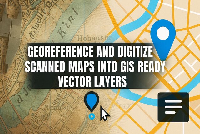
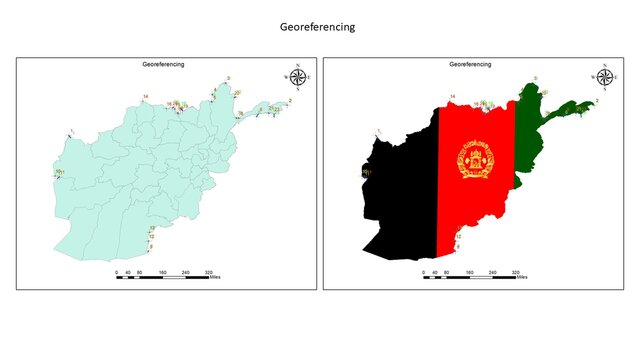
I will georeference and digitize scanned maps into GIS ready vector layers


About this service
Do you have a scanned map, PDF, old drawing, paper sketch, or any image that needs to be converted into accurate GIS vector layers?
I will professionally georeference, digitize, and convert your maps into clean and accurate GIS datasets.
What I provide:
• Digitizing any scanned map, PDF, or image
• Georeferencing to real-world coordinates
(WGS84, UTM, State Plane, etc.)
• Creating GIS vector layers:
• Shapefile (SHP)
• GeoJSON
• KML/KMZ (Google Earth)
• DXF/DWG (AutoCAD)
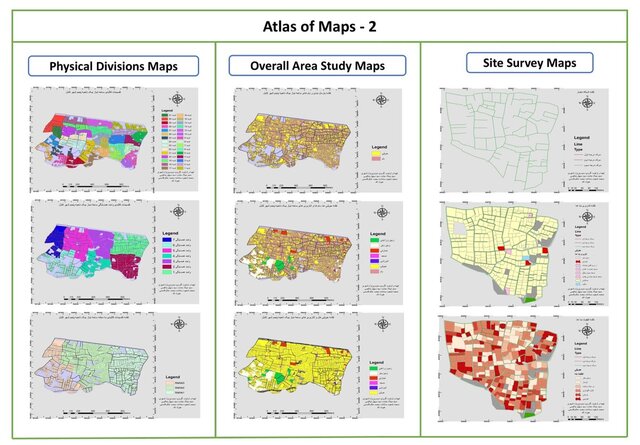
• Creating layers such as:
• Roads
• Buildings
• Land use
• Rivers & streams
• Parcels/Boundaries
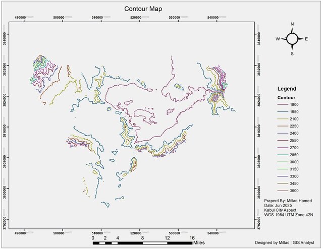
• Contours
• Clean topology (no gaps, no overlaps)
• Attribute table creation (Name, ID, Type, etc.)
• High accuracy manual vectorization
• Fast delivery & unlimited revisions for quality
Why choose me?
• GIS Specialist with experience in digitizing hundreds of maps
• High accuracy guaranteed
• Fast & friendly communication
• 100% satisfaction or full refund
Deliverables:
• SHP / GEOJSON / KML / DXF
• Well-organized layers
• Projection file (prj)
• Clean and editable datasets
If you have any special requirements, feel free to contact Me before placing order!
I will professionally georeference, digitize, and convert your maps into clean and accurate GIS datasets.
What I provide:
• Digitizing any scanned map, PDF, or image
• Georeferencing to real-world coordinates
(WGS84, UTM, State Plane, etc.)
• Creating GIS vector layers:
• Shapefile (SHP)
• GeoJSON
• KML/KMZ (Google Earth)
• DXF/DWG (AutoCAD)
• Creating layers such as:
• Roads
• Buildings
• Land use
• Rivers & streams
• Parcels/Boundaries
• Contours
• Clean topology (no gaps, no overlaps)
• Attribute table creation (Name, ID, Type, etc.)
• High accuracy manual vectorization
• Fast delivery & unlimited revisions for quality
Why choose me?
• GIS Specialist with experience in digitizing hundreds of maps
• High accuracy guaranteed
• Fast & friendly communication
• 100% satisfaction or full refund
Deliverables:
• SHP / GEOJSON / KML / DXF
• Well-organized layers
• Projection file (prj)
• Clean and editable datasets
If you have any special requirements, feel free to contact Me before placing order!
Do you have a scanned map, PDF, old drawing, paper sketch, or any image that needs to be converted into accurate GIS vector layers?
I will professionally georeference, digitize, and convert your maps into clean and accurate GIS datasets.
What I provide:
• Digitizing any scanned map, PDF, or image
• Georeferencing to real-world coordinates
(WGS84, UTM, State Plane, etc.)
• Creating GIS vector layers:
• Shapefile (SHP)
• GeoJSON
• KML/KMZ (Google Earth)
• DXF/DWG (AutoCAD)
• Creating layers such as:
• Roads
• Buildings
• Land use
• Rivers & streams
• Parcels/Boundaries
• Contours
• Clean topology (no gaps, no overlaps)
• Attribute table creation (Name, ID, Type, etc.)
• High accuracy manual vectorization
• Fast delivery & unlimited revisions for quality
Why choose me?
• GIS Specialist with experience in digitizing hundreds of maps
• High accuracy guaranteed
• Fast & friendly communication
• 100% satisfaction or full refund
Deliverables:
• SHP / GEOJSON / KML / DXF
• Well-organized layers
• Projection file (prj)
• Clean and editable datasets
If you have any special requirements, feel free to contact Me before placing order!
Do you have a scanned map, PDF, old drawing, paper sketch, or any image that needs to be converted into accurate GIS vector layers?
I will professionally georeference, digitize, and convert your maps into clean and accurate GIS datasets.
What I provide:
• Digitizing any scanned map, PDF, or image
• Georeferencing to real-world coordinates
(WGS84, UTM, State Plane, etc.)
• Creating GIS vector... read more
I will professionally georeference, digitize, and convert your maps into clean and accurate GIS datasets.
What I provide:
• Digitizing any scanned map, PDF, or image
• Georeferencing to real-world coordinates
(WGS84, UTM, State Plane, etc.)
• Creating GIS vector... read more
Do you have a scanned map, PDF, old drawing, paper sketch, or any image that needs to be converted into accurate GIS vector layers?
I will professionally georeference, digitize, and convert your maps into clean and accurate GIS datasets.
What I provide:
• Digitizing any scanned map, PDF, or image
• Georeferencing to real-world coordinates
(WGS84, UTM, State Plane, etc.)
• Creating GIS vector layers:
• Shapefile (SHP)
• GeoJSON
• KML/KMZ (Google Earth)
• DXF/DWG (AutoCAD)
• Creating layers such as:
• Roads
• Buildings
• Land use
• Rivers & streams
• Parcels/Boundaries
• Contours
• Clean topology (no gaps, no overlaps)
• Attribute table creation (Name, ID, Type, etc.)
• High accuracy manual vectorization
• Fast delivery & unlimited revisions for quality
Why choose me?
• GIS Specialist with experience in digitizing hundreds of maps
• High accuracy guaranteed
• Fast & friendly communication
• 100% satisfaction or full refund
Deliverables:
• SHP / GEOJSON / KML / DXF
• Well-organized layers
• Projection file (prj)
• Clean and editable datasets
If you have any special requirements, feel free to contact Me before placing order! read less
Service offer categories
CAD Digitization Services
Software & skills
ArcGIS
ArcGIS Pro
ArcMap
GIS / CAD Specialist
GIS Mapping
Geographic Information Systems
Raster to Vector Conversion
geospatial analysis
+5 more
This service includes
| Service tiers | Simple $10 | Standard $20 | Advanced $40 |
|---|---|---|---|
| Summary | Simple Map Digitizing | Multi-layer GIS Digitizing | Full GIS Conversion Package |
| Details | 1 layer digitizing (roads OR buildings OR boundaries) | • Up to 3 layers • Georeferencing included • Clean topology | • Up to 6 layers • Advanced georeferencing • Attribute table creation |
| Delivery time | 1 day | 2 days | 4 days |
| Number of revisions | 2 | 4 | 6 |
★ 5.0 (11)
Kabul, California, Afghanistan – 4:39 a.m. local time
Member since
October 2025
Languages
English,
Persian (Farsi),
French,
Spanish
Avg. response time
1 hour
Industrial & 3D Design Specialist | Engineering Modeling, Rendering & Geospatial Visualization
I am a professional CAD and 3D design specialist with strong experience in industrial, architectural, and engineering projects. I focus on transforming ideas into precise and realistic models that combine technical accuracy with creative vision.
My expertise includes developing detailed floor plans, elevations, and complex 3D models, along with producing high-quality renderings and visual prese... read more
My expertise includes developing detailed floor plans, elevations, and complex 3D models, along with producing high-quality renderings and visual prese... read more
Questions and answers
Yes, any scanned map, old map, PDF, layout, image, or drawing can be digitized.
Yes, I can enhance, clean, and digitize even low-quality maps.
I offer multi-layer packages or custom quotes depending on complexity.
Yes, I can export to DXF/DWG.

Cad Crowd Billing Security policy
Service quality is protected by Cad Crowd Billing Security policy.
More from Sayed Millad H.
More similar services


See related services
- 3D Design services
- 3D Modeling services
- CAD Design services
- 2D & 3D Design services
- 2D & 3D Modeling services
- CAD Modeling services
- Drafting services
- AutoCAD services
- 3D Models services
- Mechanical Design services
- Product Design services
- Mechanical 3D Design services
- Rendering services
- 2D Drafting services
- 2D Drawing services
- 2D AutoCAD services
- CAD Drafting services
- 3D Rendering services
- Architectural Design services
- SolidWorks services
- 3D Solidworks services
- Mechanical Engineering services
- 2D & 3D Drafting services
- 2D/3D AutoCAD services
- 2D & 3D Modeling Solidworks services
- Industrial Design services
- CAD Assembly services
- Mechanical Engineer services
- Design Engineer services
- CAD Conversion services
- AutoCAD Mechanical services
- FEA services
- Product Development services
- Prototyping services
- 3D Analysis and Design services
- Sheet Metal Design services