I am a civil engineer with over 10 years of hands-on experience in river engineering, flood modeling, and topographic & geotechnical drafting.
I specialize in using industry-stand...
I am Beffon O Ating’a, a highly experienced Construction Surveyor and CAD Specialist with over 8 years of international experience.
I specialize in high-precision construction surv...
I have over 15 years of experience as a skilled Civil Engineer and possess expertise in using Auto CAD, Civil 3D, and Microsoft Excel. My abilities include creating 2D drawings for...
I am a Surveying and Road Design Engineer with over 13 years of
practical experience in topographic surveying, road design, Civil 3D,
and GIS.
I help engineering consultants, cont...
AutoCAD Civil 3D Specialist | Land Survey Drafting & Site Deliverables
Spring,
TX,
United States
AutoCAD Civil 3D Drafter & Survey Specialist
I provide accurate, production-ready CAD drafting services for land surveying, site planning, and construction projects. With a strong...
My name is Swapnil Sutar, a Freelance CAD Drafting Specialist from India with over 10 years of experience supporting land surveyors, civil engineers, and mapping companies with acc...
Land Survey CAD Drafting Expert | AutoCAD Civil 3D | ALTA, Topo, Boundary Surveys
Pune,
India
I am a highly skilled CAD professional specializing in Land Survey Drafting & Geospatial Mapping with 5+ years of experience working with USA-based land surveyors, engineers, and d...
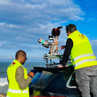
I am a surveying engineer (MSc in Geodesy) with hands-on experience on industrial, infrastructure and urban projects in Morocco and West Africa. I capture data myself (terrestrial...
Licensed Geodetic Engineer & 2D/3D AutoCAD Point Cloud Specialist
Belgrade,
Serbia
I am Milena, a licensed Master of Science in Land Surveying (M.Sc.Geod.) with over 10 years of professional experience in geodetic project management and precision CAD drafting. Ha...