I will design a 2D area summary for site planning from survey data


About this service
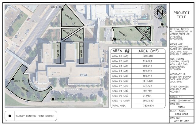
Given any form of 2D survey data, I can create a plan view showing the approximate lengths and/or areas of any requested geographical feature.
Given any form of 2D survey data, I can create a plan view showing the approximate lengths and/or areas of any requested geographical feature.
Given any form of 2D survey data, I can create a plan view showing the approximate lengths and/or areas of any requested geographical feature.
Given any form of 2D survey data, I can create a plan view showing the approximate lengths and/or areas of any requested geographical feature.
Service offer categories
2D CAD Drafting Services
Civil Drafting Services
Landscape Design
Software & skills
2D Drafting
2D Drawings
2D Site Plans
Civil Drafting
Civil Site Plan Design
Civil Survey Drafting
Land Surveying
Point Cloud Modeling
Site Design
Site Planning
+7 more
This service includes
| Service tiers | Simple $50 |
|---|---|
| Summary | Summary of Area |
| Details | Required: The point cloud or survey data must include at least two KNOWN control points with lat-long coordinates - more known control points will be more accurate. |
| Delivery time | 3 days |
| Number of revisions | 1 |
Member since
March 2026
Languages
English
Avg. response time
1 hour
Civil Engineering Technologist
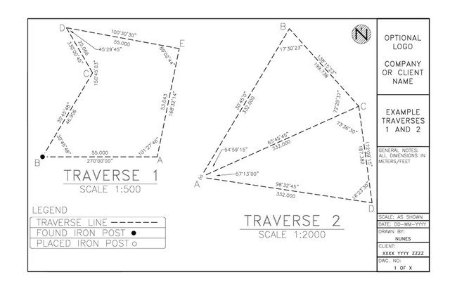
In NAIT's Civil Engineering Technology program from 2025-2027. Excellent with AutoCAD including building floor plans, traverse diagrams with scales, title blocks, layer control, and attention to detail.

Cad Crowd Billing Security policy
Service quality is protected by Cad Crowd Billing Security policy.
More from Nathan N.
From
$13/hr
More similar services


See related services
- 3D Design services
- 3D Modeling services
- CAD Design services
- 2D & 3D Design services
- 2D & 3D Modeling services
- CAD Modeling services
- Engineering Design services
- 2D & 3D CAD Design services
- Drafting services
- AutoCAD services
- 3D Models services
- Mechanical Design services
- Product Design services
- Rendering services
- 2D Drafting services
- 2D Drawing services
- 2D AutoCAD services
- CAD Drafting services
- 3D Rendering services
- Architectural Design services
- SolidWorks services
- CAD Drawing services
- 3D Solidworks services
- Mechanical Engineering services
- 2D & 3D Drafting services
- 2D/3D AutoCAD services
- 2D & 3D Modeling Solidworks services
- 2D & 3D Architectural Design services
- Floor Plans services
- 3D Visualization services
- Architectural Drafting services
- Interior Design services
- Mechanical Engineer services
- Design Engineer services
- 3D Architectural Rendering services
- Construction Drawings services