
David A.
Geospatial Analyst
 New York,
United States
Global rank:
8,462
/
155,226
Skill pts: 10
About
GIS and Remote Sensing Analyst with experience in spatial data validation, satellite imagery
analysis, and mapping across environmental, urban, hydrological, and real estate projects.
Produces maps, validated datasets, and analytical reports for research and applied GIS workflows.
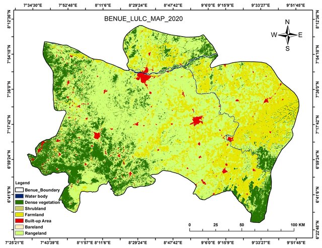
Experienced in land use and land cover classification, environmental time-series analysis,
boundary digitisation, attribute validation, and spatial quality assurance and quality control
(QA/QC). Combines remote project collaboration with practical field data collection and
environmental monitoring experience.
Uses ArcGIS Pro, QGIS, ArcGIS Online, Google Earth Engine, and R for spatial analysis and
visualisation. Recently completed certified training in Data Science with Python and is undertaking
a one-year GeoDev programme focused on geospatial development.
... more »
« less
analysis, and mapping across environmental, urban, hydrological, and real estate projects.
Produces maps, validated datasets, and analytical reports for research and applied GIS workflows.
Experienced in land use and land cover classification, environmental time-series analysis,
boundary digitisation, attribute validation, and spatial quality assurance and quality control
(QA/QC). Combines remote project collaboration with practical field data collection and
environmental monitoring experience.
Uses ArcGIS Pro, QGIS, ArcGIS Online, Google Earth Engine, and R for spatial analysis and
visualisation. Recently completed certified training in Data Science with Python and is undertaking
a one-year GeoDev programme focused on geospatial development.
Portfolio
Experience
-
GIS Data Validation Officer
DataLord Technologies · Part-time
Feb 2025 –
May 2025
3 mos
Naforija, Lagos, Nigeria
• Validated and corrected spatial and attribute datasets using ArcGIS Pro.
• Conducted GIS quality assurance and quality control (QA/QC) reviews to improve positional and attribute accuracy.
• Verified geospatial assets and maintained metadata documentation standards.
• Produced reports supporting enterprise mapping and data management workflows. -
Data Validator
Milsat Technologies (USCDC Household Mapping Project) · Part-time
Mar 2024 –
Sep 2024
6 mos
Lagos, Nigeria
• Validated household spatial datasets within ArcGIS Online environments.
• Reviewed geospatial records to ensure consistency and accuracy.
• Collaborated with field mapping teams to resolve data discrepancies.
• Contributed to public health geospatial data quality initiatives.
Education
- Obafemi Awolowo University, Nigeria MSc Remote Sensing and GIS, Remote Sensing and GIS 2024 – 2026
- Federal University of Technology Akure (FUTA), Nigeria B.Tech Remote Sensing and GIS, Remote Sensing and GIS 2016 – 2021
Other experience
-
Toronto Housing Affordability Web Mapping Project
• Built an interactive web application comparing housing affordability and real-estate pricing.
• Developed spatial visualization products to support urban planning analysis.
• Configured comparative map layers and geospatial dashboards. -
Watershed Delineation and Surface Analysis
• Delineated watershed boundaries using DEM-based hydrological techniques.
• Conducted land use and land cover analysis for watershed assessment.
• Evaluated impervious surface distribution and runoff-related characteristics. -
Geospatial Assessment of Akure Forest Reserve
• Performed NDVI, Land Surface Temperature, and LULC analysis.
• Identified vegetation degradation and encroachment trends.
• Developed maps and environmental intelligence products to support land management assessment. -
Mining Impact Assessment Using Google Earth Engine
• Assessed environmental impacts of gold mining activities using Landsat imagery.
• Conducted vegetation and land-cover change analysis.
• Generated geospatial outputs supporting environmental impact assessment.
• Produced results that contributed to a peer-reviewed publication. -
Web GIS & Visualization
• ArcGIS Online
• StoryMaps
• Web Mapping Applications
• Interactive Mapping Dashboards -
Data Analysis & Programming
• R (sf, raster, terra)
• Python
• Excel
• SPSS -
Remote Sensing & Earth Observation
• Google Earth Engine
• Landsat
• Sentinel-1
• Sentinel-2
• MODIS
• NDVI Analysis
• NDWI Analysis
• Land Surface Temperature (LST)
• Land Use/Land Cover Classification
• Change Detection
• Time-Series Analysis -
GIS & Spatial Analysis
• ArcGIS Pro
• ArcGIS Online
• QGIS
• Spatial Analysis
• Overlay Analysis
• Buffer Analysis
• Suitability Analysis
• Service Area Analysis
• Network Analysis
• Cartographic Design
• Geodatabase Management
• Spatial QA/QC
Licenses & Certifications
- Esri ArcGIS Online Feb 2026 – Present
- Esri Spatial Analysis Oct 2025 – Present
- Esri Suitability Modeling Sep 2025 – Present
- Esri GIS Basics Aug 2025 – Present
- Esri Geographic Coordinate Systems Jul 2025 – Present
- Esri Drone2Map Image Processing Jun 2025 – Present
- Skills for Africa GIS Modules Feb 2024 – Present
- Esri ArcGIS Pro Basics Jan 2024 – Present
Verified info
- Email address
Stats
0 followers, 0 following
Age: 31
Joined: October 25, 2026
Last seen: November 2, 2026
Languages
English Full professional proficiency
Location
New York, NY, United States